
North Hempstead Neighbors: What Block Records Can Show
Public records around a North Hempstead address answer different questions. The Nassau map can identify the adjacent polygons; the assessment record can describe the parcel; the County Clerk index can identify recorded parties; and a dated local collection can provide historical context. No reviewed official source supplied a Town-wide public resident roster, and the public voter form cannot be used to browse everyone on a block. This coverage table separates the evidence from the inference.
| Source | What it shows about a block | Access |
|---|---|---|
| Nassau GIS / LRV map | Adjacent parcel polygons, roads, lots, aerial and historical layers | Public map, click and pan, with parcel-layer metadata. |
| LRV parcel detail | SBL, Town or village, school label, class, values, and deed reference | Public viewer with captcha or optional account behavior. |
| County Clerk index | Recorded grantors, grantees, instruments, and dates | Free index; images and certified copies have separate routes. |
| Town or village property file | Address-linked permits, inspections, certificates, and notices | FOIL or property-file request; jurisdiction varies. |
| Town civic list | Association names and public contact methods | Public list, not a member roster. |
| PWPL collections | Dated directories, Beacon Hill papers, oral histories, and maps | Digital, microfilm, or reference access depending on material. |
| NYS voter systems | Individual registration match or regulated file fields | Public form is person-first; file request needs an elections purpose. |
A parcel border is not a household list. A lot can be a separate tax parcel, a common area, a road, a condominium unit, or part of a larger lot group, so each North Hempstead neighbors result needs the underlying parcel record and source date.
Map a North Hempstead Block One Parcel at a Time
The Nassau GIS Map Viewer and LRV map support the right first step: locate a target address, turn on parcel and lot layers, and click the surrounding polygons. The parcel-layer REST metadata exposes PARID, PARCEL_ADDRESS, ROLL_YEAR, geometry, and related fields. It also documents query, statistics, pagination, and distance support, but the reviewed public text did not confirm an automated address-radius tool. Do not promise a buffer result until the live map control is verified.
The Nassau parcel-layer schema shown below helps explain which fields belong to the map layer. The map supplies geography; LRV and the Clerk supply the parcel and title context.
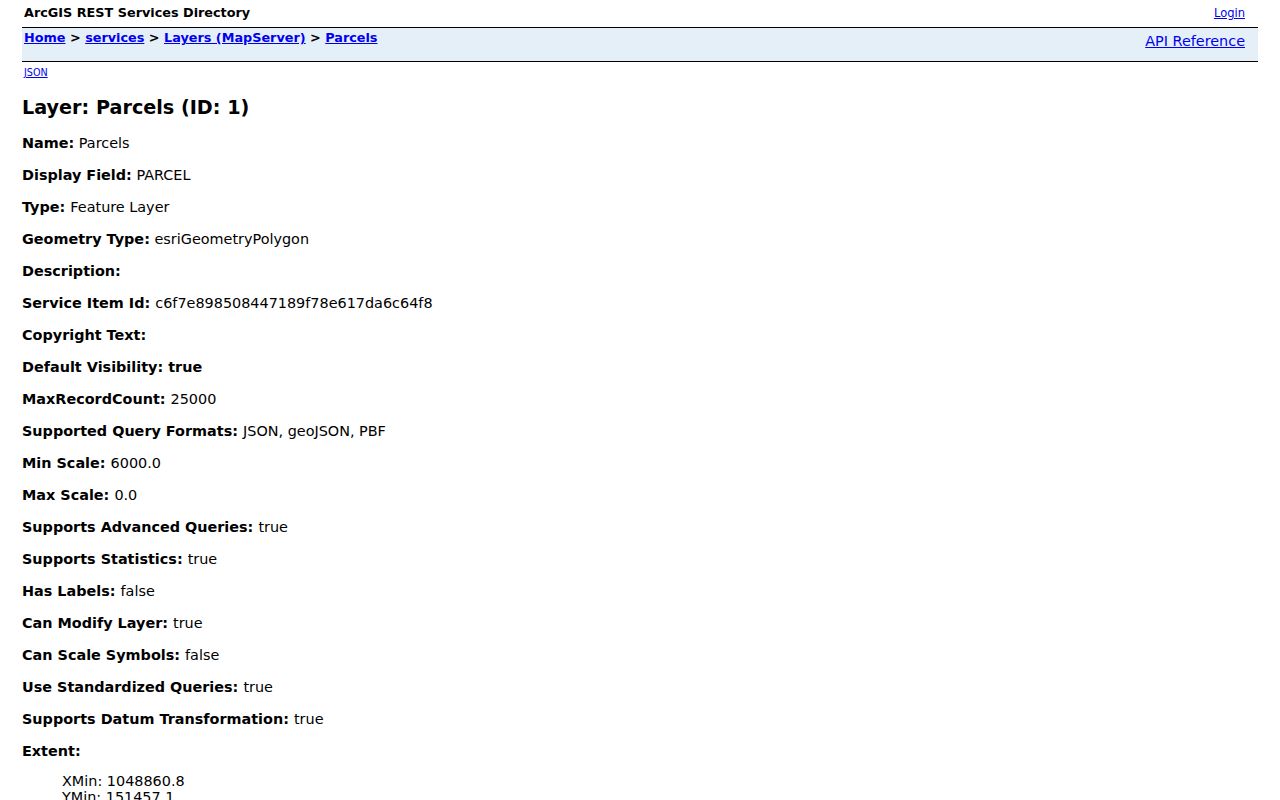
Save the exact PARID, parcel address, and roll year for each selected polygon. Then use the SBL or parcel details to test whether the polygon is relevant before examining its ownership history.
- Enter the target address in LRV, then open the LRV map or Nassau GIS map.
- Turn on Parcels or Lots and road labels, zoom to the street segment, and click each adjoining polygon.
- Record the parcel address, PARID, SBL, and roll year instead of guessing from house-number order.
- Open each LRV parcel card for the Town or village, school, class, and deed-reference fields.
- Use the County Clerk index only when an ownership-history question requires the recorded instrument.
Read North Hempstead Neighbor Parcel Cards Carefully
LRV combines assessment-roll and parcel information, including tax maps, district information, photographs, tax history, exemptions, comparable sales, and a GIS link. A result can show the parcel address, Town or village, SBL, tax class, value, taxes, recent sales, and a deed or liber-page reference. The sample research card at 23 West Drive, Plandome shows how one parcel can carry a village label, Town North Hempstead, Manhasset-6 school, SBL 3-009-223, and a deed reference without publishing a person's name.
Property address and owner mailing address are different fields. The free interface may not expose every mailing field, and the research does not support promising that it does. Request a property record card from Nassau Assessment if that distinction is essential. The assessment roll and a recorded deed also update on different schedules, so compare source dates rather than selecting one as the final answer.
Map tip. LRV's historic layers include Nassau County 1926 and 1950 maps and Aerial 2013, useful for testing a block's physical continuity.
North Hempstead Neighbors and Civic Association Contacts
The Town's official civic-association list is a community layer, not a directory of people at nearby parcels. It names organizations in Albertson, Carle Place, East Hills, East Williston, Great Neck, Manhasset, Mineola, New Cassel, Port Washington, Roslyn, Westbury, Williston Park, and other Town communities. The public list often gives a contact, postal address, phone number, email, or website, but it does not establish membership from an address. Some organizations are marked dormant.
Use the public contact to ask about meeting information or how to join, not to infer a current roster. A few examples in the official list make a useful starting set:
| Association or umbrella group | Listed public contact detail | Use of the listing |
|---|---|---|
| Albertson Civic Association | PO Box 14, Albertson NY 11507; 516-840-8115 | Community contact, not a member list. |
| Carle Place Civic Association | PO Box 131, Carle Place NY 11514; 516-761-1896 | Public organizational contact. |
| Council of Greater Manhasset Civic Associations | 917-270-6987; info@manhassetcivic.org | Umbrella civic contact. |
| Plandome Association | plandome.org | Use the official site for public information. |
North Hempstead Neighbors in Historical Community Sources
When the question is historical rather than current, Port Washington Public Library's Local History Center is a strong local fallback. Its collection guide includes telephone directories, maps, school records, civic-association papers, landowner papers, and oral histories. The Beacon Hill Residents Association papers preserve membership lists, minutes, by-laws, newsletters, maps, and budgets for 1926-1973. They are a time-bounded archival source, not a current list of neighbors.
The Town's library list also identifies independent library districts serving local communities. Library districts are independent under New York Education Law, so use the listed branch or reference contact that serves the community being researched. For Port Washington historical collections, PWPL is especially useful; for a different community, a local library may help identify maps, newspapers, and village history resources.
For an archive request, provide a street, community, approximate years, and the narrow question being tested. Ask whether the response comes from an index, scan, finding aid, oral-history transcript, or uncatalogued box, then preserve the collection title and date consulted.
The Town page supplies usable human fallback contacts when a web search ends: Port Washington Public Library is listed at 516-883-4400, Manhasset at 516-627-2300, Great Neck Main at 516-466-8055, Roslyn and Roslyn Heights at 516-621-2240, and East Williston at 516-741-1213. Call the library that serves the relevant community and ask about a named collection, map, newspaper, or historical directory rather than asking staff to identify everyone near an address. Collection limits and access conditions should be recorded with each answer.
North Hempstead Neighbors Are Not an Open Voter Roster
The public NYS voter lookup asks for County, last name, first name, date of birth, and ZIP. It is designed for a known person's registration, poll-site, or mail-ballot status, not a block browse. Cookies and JavaScript are required. Select Nassau for North Hempstead, and do not read a no-match as proof that someone is absent. A spelling variation, ZIP issue, administrative status, or protected record can explain it.
A statewide voter-file request has far more residence, mailing, district, status, and history fields, but New York Election Law §3-103(5) requires an elections purpose. Confidential registration under Election Law §5-508 is unavailable to the public for the stated statutory period. Property adjacency is a map task; identifying a person from election data is a separate, limited process with its own rule.
North Hempstead Neighbor Tools: Official Records Versus Compiled Listings
Official sources preserve a source-specific trail: a GIS layer explains parcel location, an assessment record describes the parcel, a deed index identifies an instrument, and a library source dates a historical appearance. They can be slower to combine, but their custody and limits are visible. A commercial neighbor-lookup category may blend property, directories, marketing material, and inferred associations, often without a clear record date or correction path.
| Approach | Strength | Limit to remember |
|---|---|---|
| GIS plus LRV | Shows the parcel geometry and its assessment context | Does not identify every person associated with the address. |
| County Clerk index | Documents recorded parties and dates | Recorded title is not a current household statement. |
| Library and archive material | Adds date-specific neighborhood history | Coverage varies by collection and year. |
| Compiled commercial category | May gather scattered leads in one place | Can be stale, mix similar names, or lack a source trail. |
For a full road rather than the immediate block, use the North Hempstead street directory to follow the address-keyed record chain. It is a different task from mapping adjacent parcels.
Privacy Limits for North Hempstead Neighbors Research
Some information stays private by design: household membership, utility accounts, postal delivery records, DMV information, unlisted telephone service, confidential voter records, address-confidentiality participants, and sealed court or vital files. An owner's mailing address may also differ from the parcel's situs address. Do not present an old record, map label, or parcel border as a current personal location without a dated source that supports that limited statement.
When an existing Town property file is needed, make a focused FOIL request through the Town's online or paper route and identify the address or SBL, date span, permit type, and document sought. New York FOIL is an access law for records, not a demand that an agency conduct open-ended research. A request may be granted, denied, or acknowledged within five business days, with an approximate completion date when more time is needed. An appeal route exists for a denial, but it does not overcome confidentiality or privacy rules.
Lawful use. Use North Hempstead neighbor records for civic curiosity, family history, property research, and legitimate community contact. Do not use them to watch, harass, intimidate, or harm anyone.